
Projects
Mapping of oceanic and coastal environments of the Republic of Mauritius: Component - Ecological survey (incl. bleaching assessment) of nearshore waters of Mauritius
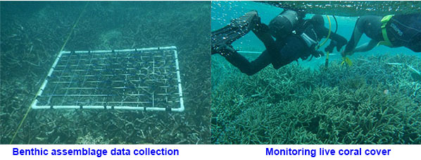
In Mauritius, coral reefs play a critical role in the socio-economic development of the island whereby healthy coral reefs significantly contribute to coastal protection, fisheries and tourism industries and also for the preservation of biodiversity. Despite their importance, the reefs of Mauritius, like other reefs worldwide, are being impacted by climate change and other anthropogenic and natural disturbances. To investigate the response of coral species to environmental stressors, the MOI initiated an ecological monitoring programme of the nearshore waters of Mauritius in 2010. Permanent stations have been established inshore and offshore at different sites around the island where spatio-temporal data for biological and chemical parameters are regularly collected. Long-term data collected through this study will help in (i) providing insight into ecological processes that underlie reef resilience, (ii) understanding human impacts on coral reef ecosystem, (iii) generating data for use in multidisciplinary coastal studies, (iv) providing a better understanding of climate change impacts on coral reef ecosystem on a short-term as well as on a long-term basis, and (vi) informed decision making to reverse the current trend in reef degradation. Click for more details
Project objective(s):
- To collect long term biological and physico-chemical data at selected sites around Mauritius.
- To carry out surveys/bleaching surveys at selected sites around Mauritius.
Project team:
S.Bacha Gian, S.Curpen, Dr. D.Dumur-Neelayya, Dr Y.Neehaul, P.Oogarah, A.Nicolas, G.Kalleechurn,C.Samyan, S.Sunassee
Biological Survey of Port Mathurin Harbour to Detect Introduced Species
Port Biological Baseline Survey is a multidisciplinary scientific survey conducted periodically to assess a port’s biological communities and ecology, with focus on the identity, distribution and abundance of Non-Indigenous Species (NIS), some of which may be ecologically damaging and invasive. The current grant aims at conducting the first port baseline survey of Port Mathurin, Rodrigues, so as to provide an inventory of the natural populations, including a catalogue of existing introduced species. This will contribute, for instance in the development of Ballast Water Management strategies and measures for our ports.
Objectives
- To conduct and report on the port biological survey for marine invasive species in Port Mathurin, Rodrigues.
- To conduct training and capacity building of RRA designated scientist/ technical counterparts in port baseline survey.
- To conduct an awareness campaign with shipping, fisheries together and environmental community in Rodrigues.
Project team
P. Mussai, K. Ramdhony, R. Sooroojebally , V. Ramchandur, B. Motah, S. Bacha Gian, C. Samyan, S. Sunassee
Ships’ Biofouling in Port Louis Harbour
Marine biofouling occurs mainly through attached or sessile marine species. Shipping has been identified as the major vector for the spread of invasive aquatic species on a global and regional scale and the resulting transfer and introduction of invasive aquatic species through ship’s biofouling threatens the conservation and sustainable use of biological diversity. In context and pertinent to the 2011 Guidelines for the Control and Management of Ship’s Biofouling to Minimize the Transfer of Invasive Aquatic Species, this project aims at developing a standardized template for hull inspection as a decision support tool and its application to survey invasive aquatic species related to biofouling.
Objectives
- Development of standardized template for hull inspection (inspection and sampling)
- Collection of data on selected vessels (in dry-dock and in-water) arriving in Port Louis harbour using developed standardized sampling methodology, to provide baseline information on the nature and extent of biofouling.
- Description on the composition and patterns of biofouling on the selected vessels (in dry-dock and in-water)
Project team
P. Mussai, K. Ramdhony, R. Sooroojebally , V. Ramchandur, B. Motah, C. Samyan, S. Sunassee
Assessment of living resources in the EEZ of Mauritius
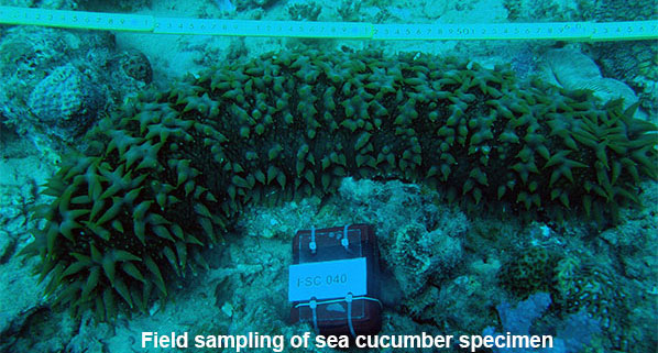
Marine biodiversity is under constant stress from human activities and climate change, with a large number of species becoming extinct even before being documented. The marine ecosystem in Mauritius is no exception, as it faces continuous coastal habitat degradation and over-exploitation of its marine living resources. In this context, it is critical that the existing organisms present in the Mauritian waters are properly identified and inventoried using contemporary tools such as DNA-based techniques that have the advantage of being rapid, accurate and cost-effective in comparison with more conventional techniques.
The MOI is currently undertaking an assessment of marine living resources using both taxonomy and DNA-based technique. The project is in line with the Government programme 2015-2020 as well as with its Vision 2030, whereby protection and preservation of marine living resources is key to the establishment of a sustainable Ocean Economy.
While the initial focus of the project has been on fish of commercial importance, the project is currently assessing sea cucumbers (holothurians) inhabiting the Mauritian waters. As an ongoing MOI’s project, the DNA-barcoding of other marine taxa (molluscs, crustaceans, corals) will be implemented. The data generated from the project is uploaded on the online Marine Diversity and genetic database of the MOI.
Objectives:
- To undertake an inventory of marine living resources using taxonomy and DNA-based techniques.
- To establish and populate an online marine living resources and genetic database.
- To provide services to the seafood and aquaculture industries.
- To publish posters and field guides (use by various stakeholders incl. aquaculture investors).
Project team
S. Curpen, Dr. D.Dumur-Neelayya, S. Bacha Gian, L. Harree-Somah, C.Samyan, S.Sunassee
Mapping of oceanic and coastal environments of the Republic of Mauritius; Component - Plankton assessments in the EEZ of Mauritius including outer islands (Seamounts and FADs)
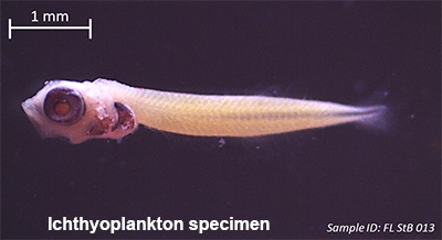
It is well known that planktonic stages of most marine organisms are attracted and aggregate around solid objects in the ocean. These may include submerged as well as floating objects such as seamounts and fish aggregating devices (FADs). Presently, the Republic of Mauritius lacks data on plankton dynamics in its EEZ. Hence, the MOI has initiated a plankton study in the EEZ of the Republic of Mauritius. The project which is in line with the Government’s Vision 2030 and MOI’s Strategic Plan 2016-2020, aims at determining and comparing plankton communities occurring at seamounts, FADs, outer islands and at earmarked aquaculture sites. Collected plankton samples will be identified through microscopy complemented with a DNA-based approach. Additional studies including (i) gene flow/genetic connectivity (if any) among sampling stations, and (ii) factors (physical and chemical) influencing the plankton distribution at sampling stations will also be undertaken. Data generated through this study will help in (i) complementing the study on inventory of marine organisms in the EEZ of Mauritius, (ii) updating the database of Marine Organism with molecular and taxonomic data, and (iii) identifying possible planktonic organism with biotechnological applications for future exploitation.
Project team:
S. Bacha Gian, Dr. D.Dumur-Neelayya, S. Curpen, L. Harree-Somah, C.Samyan, S.Sunassee
Mapping of oceanic and coastal environments of the Republic of Mauritius: Component - Multidisciplinary survey of Agaléga islands
In view of risk and disaster management of the island of Agaléga, it is important to have a comprehensive survey that would enclose the marine and coastal features of the island. In this regard, the MOI will undertake a comprehensive survey of the north and south islands of Agaléga in 2017. Physical, chemical and biological data in terms of bathymetry, wave and tide regime, temperature and salinity, water current pattern, nutrient levels, pH, dissolved oxygen, mapping of habitats and its surrounding species and as well as coastal elevation will be collected at selected locations around the islands. All the data generated will be integrated in a GIS platform to be housed at MOI. These data will be provided to potential investors for development of the marine sector in Agaléga, including aquaculture and port development. Collected data will also be helpful in (i) the generation of a Tsunami inundation map for the Agaléga islands, (ii) identifying ocean/coastal hazard and hence provide possible mitigative measures, and (iii) providing a tool for sustainable marine planning and resource management applications.
|
Objectives: Biological component
Project team: S. Bacha Gian, Dr. D.Dumur-Neelayya, S. Curpen, O.Sadasing, L. Harree-Somah, C.Samyan, S.Sunassee Chemical Oceanography At present chemical data on the marine environment in Mauritius is scarce. Through this novel multi-disciplinary investigation, earmarked aquaculture sites are characterised to provide spatial and temporal data on the marine environment. Three significant factors are applied to produce undisputed and high quality data: (a) the design and performance of a sampling programme to be the most representative of the site under investigation; (b) the selection and use of suitable pre-treatment and storage procedures for samples to limit variations in concentrations and speciation prior to further treatment in the laboratory; and (c) the adoption of analytical protocols which enable measurements of appropriate precision while always taking account of the specific matrix of seawater. Project Team: Dr. Yashvin Neehaul, Preeti Oogarah, Geetika Kalleechurn |
 |
Community based coral culture in the Republic of Mauritius
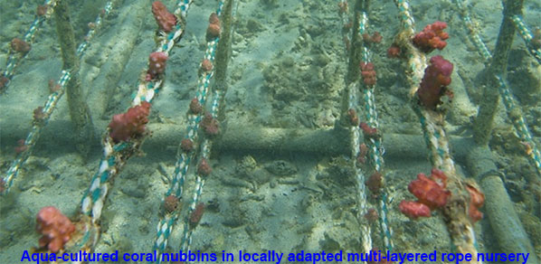
Over the past few years, the MOI has successfully developed and optimised locally adapted techniques for culture of corals on-land and at sea for conservation purposes. The institute has recently initiated a community based coral culture project in the Republic of Mauritius. This three year project primarily aims at training and capacity building of coastal communities in coral farming and reef rehabilitation techniques hence providing additional skills to the communities. The project which falls under the budgetary measures for the financial year 2017-2018 (Budget para-104) will be implemented at four locations around the island.
Main components of the project include:
(i) An awareness raising programme for sensitisation of stakeholders, local communities and the public at large.
(ii) Registration of participants under a “Coral Farming Training Programme”.
(iii) Set up of demonstration sea-based coral farms for culture selected coral species.
(iv) Creation of demonstration coral gardens.
(v) Training of registered participants as follows:
• Theoretical training through lectures and classroom courses.
• Practical/field training in swimming, diving and snorkelling.
• Training in coral biology, coral farm set up, management and maintenance, coral pruning, coral propagation, creation of coral gardens amongst others.
(vi) Formation of eco-guides for guided visits to coral farms and coral gardens.
Timeline:
2017 - 2020
Project team:
MOI: S. Bacha Gian - Research Scientist (Project leader), O. Sadasing – Associate Research Scientist, D. Dumur-Neelayya – Associate Research Scientist, R. Boyjoonauth – Public Relations Officer, C. Samyan – Senior Technical Officer
AFRC: S. Ramah-Technical Officer, S. Leckraz-Scientific Officer
Assessing the Submarine Groundwater Discharge Flux to Meet Potable Water Demand and Improve Domestic Water Supply in Coastal Regions
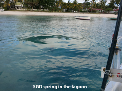
“Water flows from the land to the sea in rivers – that is the classroom picture that seems too self-evident to question. But there is evidence that a comparable amount may flow underground directly into coastal waters”
Thomas M. Church, Nature Vol. 380, 18 Apr 1996.
Water flows from land to the sea through rivers and via underground routes whereby groundwater enters the ocean from the seabed. Depending on the geological structures present, there is a mixing zone at the interface between sea water and fresh groundwater, that governs the physico-chemical parameters of the water. Essentially, groundwater discharge is rich in essential minerals such as zinc, copper and magnesium which are required for the thriving of various organisms in a near shore ecosystem.
In this study, the MOI has identified the major sites around Mauritius where groundwater enters the near shore lagoon. This investigation used satellite differential sea surface temperature imagery and in-situ measurement of naturally occurring radio-tracers to identify the major groundwater discharge sites. The quality and the flux of groundwater entering the lagoon of Trou aux Biches is under investigation.
Project Team: Dr. Yashvin Neehaul, Preeti Oogarah, Geetika Kalleechurn
Investigation of land sea interactions through groundwater discharge
Coastal oceans represent the major interface between humans and the marine environment, making coastal ecosystems the most heavily impacted by human activity through land-sea interactions. There is a general misconception that land-sea interactions involve uniquely flow of surface water to the ocean. Intertidal recirculation and submarine groundwater discharge are major routes for the transport of materials from land to the near shore marine environment, but are often neglected.
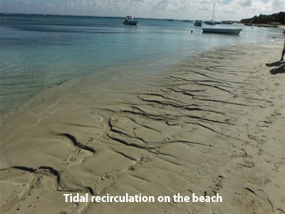
In the report entitled Water Quality Management of the Northern Aquifer of Mauritius from the Water Resources Unit and part of the UNDP funded, Integrated Water Resource and Wastewater Management in Atlantic and Indian Ocean SIDS/ Mauritius project, the main threats that may contaminate the Northern aquifer have been identified. A geo-referenced platform that includes all the areas with intensive agriculture, inappropriate sewage system and industrial zones has been setup. This GIS tool provides an excellent support in the identification of areas that pause a threat in the contamination of surface aquifers and directly the marine ecosystem. Moreover, the report recommends to:
- Assess the interaction between groundwater, surface water and coastal ecosystems.
- Determine whether groundwater is a pathway for seawater contamination, in order to avoid threats to the coral reef ecosystem and protect the vulnerable coastal lagoon.
Project Team:
Dr. Yashvin Neehaul, Preeti Oogarah, Geetika Kalleechurn
Evaluating the Anthropogenic Accumulation of Micro-Plastics across Mauritian Waters
The contemporary world has seen an increase in the use of petroleum based products, one of which is plastic. The durability of plastics, while a valuable commodity for societal purposes, has also led to high levels of plastic contamination in the environment. While the scale of the plastic production has expanded over the years, the effect of inappropriate disposal of plastic products on the environment has not been accounted for. Back in 2010, Jambeck et al. estimated an astonishing 4.8 to 12.7 million metric tons of plastic entering the ocean. This value is expected to increase significantly in this century.
The resilience of plastics in the environment has led to the categorisation of plastics into two types: 1) macroplastic which constitute large plastic debris visible to the naked eye and; 2) micro plastics, commonly known as plastic debris of less than 5mm in diameter, constitute of both macroplastic that have been mechanically degraded over time and plastic particles of microscopic size typically used in cosmetics.
The aim of this project is to assess the amount and type of microplastic present in the waters of Mauritius. The data collected will then be used as: (1) a baseline indicator to monitor trends and patterns of microplastic accumulation in Mauritian waters; (2) for further studies on their impact on marine organisms upon ingestion and potential impacts on human beings based on the polymer content of the microplastic.
In this new project, the impact of both submarine groundwater discharge and intertidal recirculation on marine ecosystem will be investigated in the Northern part of Mauritius. This project will provide a temporal indicator of the recommended measures being implemented on land in the Water Quality Management of the Northern Aquifer of Mauritius by the WRU.
Project Team:
Dr. Yashvin Neehaul, Preeti Oogarah, Geetika Kalleechurn
Tsunami Preparedness Map
Within the framework of the setting of a tsunami early warning system for the Republic of Mauritius, the Mauritius Oceanography Institute (MOI) was mandated by the Prime Minister’s Office to develop a tsunami preparedness map to identify areas of the coastal zones that would be at risk in the event of a tsunami. In this context, the MOI worked on model estimating inundation due to a tsunami and developed a tsunami inundation map for Mauritius and Rodrigues. These maps have been used by the National Disaster Risk Reduction Management in their evacuation plan and will help to preserve and safeguard the life of people and economic assets. This project is being carried out by the MOI.
Bioprospecting of Mauritius Waters (Biological activities of marine natural substances from Mauritius Waters)
The rich diversity of the Oceans offers important economic opportunities through the sustainable exploitation of our marine resources to develop drug leads for the pharmaceutical sector. Over the last five decades, a number of marine natural products have been exploited as new drugs especially in anti-cancer drug discovery (i.e. Yondelis®, Halaven® and Adcetris®). Mauritius has a rich and unique biodiversity of marine fauna and flora that offers a vast potential for discovering novel bioactive compounds. In that respect, the aim of this project is to investigate the biological activities of marine organisms to find natural products potent against human diseases. This research has identified various species of marine sponges, whose extracts have shown active properties against diseases such as Cancer, Alzheimer and Diabetes Mellitus. Currently, these active extracts are being purified to find bioactive substances, which can be developed into potent drugs.
This endeavour is in line with the mission statement of the Ministry to harness the potential of the EEZ (Exclusive Economic Zone) and to develop the Ocean Economy
Objectives
- Inventory of marine sponges in the Mauritius Waters.
- Investigating the biological properties of sponge extracts.
- Isolation and characterization of bioactive compounds.
Project team: Avin Ramanjooloo, Prerna Roy, Preeti Oogarah
Mapping of oceanic and coastal environments of the Republic of Mauritius; Component- Characterizing and mapping of coastal and oceanic environments
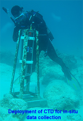
The overall goal of the project is to characterize the oceanic and coastal environment of the Republic of Mauritius by studying the physical, chemical and biological properties of Mauritius. The project will also look into the marine and coastal land use while evaluating the health of our coastal marine ecosystem to aid in regional marine planning. In addition, collecting data on the water energy regime and baseline information on living and non-living resources will provide necessary knowledge for their optimum use. The physical oceanography unit provides spatial and temporal data on the marine environment that measure parameters such as bathymetry, conductivity, temperature, salinity, water density, fluorescence, turbidity, pressure, wave, current speed and direction. These data will provide information pertaining to ocean renewable energy, marine tourism, identify ocean hazards, mitigation needs, marine conservation and planning. The data will be translated on a GIS database which will allow the synergy among the components making up the marine coastal ecosystem. It will provide relevant information to enhance existing policies and aid in decision making for the implementation of sustainable coastal development.
Project Objectives:
- To provide a tool for sustainable marine planning and resource management for decision making by the Government.
- To aid potential investors in the field of aquaculture or marine ocean investment in the development of ocean economy.
- To establish a benchmark for monitoring the status of our coastal and oceanic waters.
- To collect and analyze physical oceanographic baseline data
Team Leader: Dr. B.A. Motah (Research Scientist, RS), V. Ramchandur (RS)
Staff Involved:
Scientific staff: K. Modoosoodun (ARS), O. Gooroochurn (ARS), M. Sadien (ARS), J. R .S. Doorga (Service to Mauritius, STM)
Supporting staff: C. Samyan (Senior Technical Assistant, STA), S. Sunassee (Technical Assistant, TA)
Development of an inundation map in case of Tsunami based on updated data
To enable the development of a tsunami warning and mitigation system for the Indian Ocean, the IOC/UNESCO conducted a series of meetings for all the countries in the region to work towards the establishment of such a system. As an active stakeholder in the development of a regional tsunami warning centre, the Government of Mauritius produced a national report depicting the responsibilities and the course of action of all relevant institutions for the establishment of a national tsunami warning system. One of the components of the work plan, the assessment of national tsunami risk (hazard assessment) was entrusted to the Mauritius Oceanography Institute (MOI). The main objective was to produce an inundation map which would show coastal areas that could be impacted by a tsunami. The MOI has developed its capacity in the preparation of a Tsunami Preparedness Map based on modelling outputs of tsunami events. The modelling of tsunami events were carried out based on mathematical simulation using MOST (Method of Splitting Tsunami) model developed by the NOAA Center for Tsunami Research to assess potential risk. The generated maps are eventually submitted to the National Disaster Risk Reduction and Management Centre of the Ministry of Social Security, National Solidarity and Environment and Sustainable Development to design and plan evacuation strategy in the event of a Tsunami for the Republic of Mauritius.
Project Objectives:
- Gather bathymetry and elevation data for the Republic of Mauritius to update tsunami model output.
- To model tsunami scenarios for the Republic of Mauritius.
- To generate tsunami risk maps.
Team leader: Dr. B.A. Motah (Research Scientist, RS)
Staff Involved:
Scientific staff: V. Ramchandur (RS)
Mapping of oceanic and coastal environments of the Republic of Mauritius; Component - Development of an ocean database
The collection of oceanographic data is important for understanding the ocean and the climate system and the impacts of stressors such as climate change on marine resources. Moreover, Small Island Developing States such as the Republic of Mauritius which relies heavily on its ocean resources need sound oceanographic data for informed decision making for the sustainable development and management of ocean resources. The Government of Mauritius has emphasized the importance of dissemination of ocean information through the harmonization and standardization of ocean data thus enabling accessibility to a wider community. Mauritius has embarked on an ocean data management project which needs to be expanded both spatially and temporally across its EEZ over the next five years, starting 2018. This project is not only to allow information accessibility to users but also to give a temporal and spatial perspective for the sustainable development of the ocean and its resources. GeoNetwork is a standard based and decentralized spatial information management system, designed to enable access to geo-referenced databases and cartographic products from a variety of data providers through descriptive metadata, enhancing the spatial information exchange and sharing between organizations and end users. The main goal is to increase collaboration within and between organizations for reducing duplication and enhancing information consistency and quality and to improve the accessibility of a wide variety of geographic information along with the associated information, organized and documented in a standard and consistent way.
Project Objectives:
- Compilation of metadata for oceanographic data of the island of Mauritius.
- Development of a metadata for oceanographic data around the Island of Mauritius on the webpage on the Mauritius Oceanography Institute.
- Compilation of oceanographic metadata and data for setting up of a geo-referenced database.
- Setup of a GeoNetwork database related to ocean data.
Project Leader: Dr. B.A. Motah (Research Scientist, RS)
Staff Involved:
Scientific staff: V. Ramchandur (RS), K Modoosoodun (ARS), O. Gooroochurn (ARS), E. Martial (SA)
Satellite remote sensing: Operational service and ocean indicators and Regional Ocean Modelling System (ROMS) /Long term variation of sea surface temperature and chlorophyll-a concentration in the Indian Ocean using remote sensing
An understanding of physical, chemical and biological processes in the oceans requires regular and long-term observations. Only with such temporally extensive data sets, real long-term trends in environmental drivers (e.g. a rise in temperature or decreasing pH) and their long-term biological consequences from the natural variation can be differentiated. The decadal variability of the Indian Ocean (IO) impacts the islands of the Republic of Mauritius. It is noted that cyclonic impacts over the island has changed for more than a decade and it is known that ocean temperature is one of the key factors contributing to formation of cyclones. Therefore, IO SST variation have large climatic impacts, both on global, regional and local scales. In the context of this project, the setting up of an operational system for the IO is essential for monitoring the state of the ocean and eventually forecasting through numerical modelling of ocean impacts such heat waves, affecting coral bleaching; wave impacts on the coastline and ocean current for search and rescue operations.
Project Objectives:
- Develop long term ocean monitoring services for the South West Indian Ocean (SWIO).
- To observe the state of the ocean in the region in the EEZ of Mauritius based on ocean parameters such as Sea Surface Temperature, Chlorophyll –a, Geostrophic current, wave height and others,
- Seasonal monitoring of the ocean and after cyclone effects in the open ocean related to fisheries.
- Generate regionally downscaled climate forecasts for the western Indian Ocean base on model output
- Develop ocean indexes to monitor influence of the ocean in our waters and coastal region.
Project Leader: Dr. B.A. Motah (Research Scientist, RS), V. Ramchandur (RS)
Staff Involved:
Scientific staff: K.Modoosoodun (ARS), M. Sadien (ARS)


