
Completed Projects
Marine renewable energy resource assessment of Mauritius: Theoretical approach and electricity generation
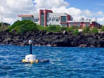
In 2017, the MOI embarked on a project involving the tapping of surface wave energy using an oscillating water column principle. The main objective of the project is to showcase the possibility of generating electricity from waves using a low-cost device. A two-phase approach was initially used for the successful completion of the wave energy conversion prototype. The first phase involved the construction of the floating platform and air chamber by the MOI whilst the second phase was mostly targeted at implementing the power take-off module by collaborators from the University of Mauritius. After numerous trials and testing, the prototype is finally operational and is successful at converting energy from waves into electricity. The launching was performed on the 29th August 2019 by the Hon. Minister of Energy and Public Utilities in the presence of the Hon. Minister of Ocean Economy, Marine Resources, Fisheries and Shipping. click for more info.
Articles have been published in some of our media. click to view more
Main Staff: Jay Doorga, Murughen Sadien, Oomarsing Gooroochurn, Olivier Pasnin, Khishma Modoosoodun-Nicolas
Staff Involved: Shane Sunassee, Chettanand Samyan, Arnaud Nicolas, Oocheetsing Sadasing, Vimal Ramchandur, Beenesh Motah, Vinay Munsah, Azagen Coopen, Vishwamitra Rishi, Prathav Askoolum, Neermala Mudhoo, Kunal Kutwaroo, Ruben Louis
Collaborators: Dr Roddy Lollchund, Dr Doobayparsad Baijnath from University of Mauritius
Marine Dynamics of Tamarin Bay Estuary, West Mauritius
The temporal distribution of salinity, turbidity, pH, chlorophyll, wave, conductivity, pressure and current of the seabed at a depth of about fourteen metre were analysed from March to April 2014.
The main objective of this project was to summarize recent knowledge of the Tamarin estuary, integrating physical, chemical and biological measurements to explore the mechanisms responsible for the transport of water, salt and chlorophyll at the mouth of the river in this lagoon and to understand the current pattern. Information will be provided to stakeholders for a proper management of the estuary and its coastal surroundings. It will also help in coastal management, beach erosion and coastal stakeholders and community at large.
African Monitoring of the Environment for Sustainable Development (AMESD)
The MOI had implemented a four-years' EU-funded project entitled African Monitoring of the Environment for Sustainable Development (AMESD) in collaboration with the African Union and the Commission de l'Ocean Indien. This project involved the reception and processing of real-time satellite images for the determination of Potential Fishing Zones and for monitoring physical oceanography parameters. (Contractual Project)
The implementation of the AMESD project by the MOI has enabled Mauritius to receive a satellite receiving station. This station has improved access to Earth Observation data and provided the country with baseline remote sensing data on chlorophyll-a and sea surface temperature at 1 km resolution. Furthermore, through the project a Wave Data Buoy that measures wave height and direction in near real-time was acquired for Mauritius. The Wave data received was disseminated to Mauritius Met Services on a 3 hourly basis.
The biological and physical characteristics of the waters in the South West Indian Ocean (SWIO) region and around Mauritius are not well known because of the scarcity of relevant information. The products developed by MOI during AMESD attempted to make up for this by providing a bulletin with a first level of interpretation of chlorophyll-variability around Mauritius and a referential database of the physical oceanography parameters for the SWIO region. This project has enabled MOI to provide useful information on the evolution of variables such as Chlorophyll-a, Sea Surface Temperature and marine currents around Mauritius and in the region. Also a desktop study of the accuracy of the Potential Fishing Zone maps in the EEZ of Mauritius was carried out with VMS data received from the Albion Fisheries Research Centre. There was a good correlation between the PFZs and the VMS data.
- Wave data disseminated to Mauritius Met Services on a 3 hourly basis used in the formulation of daily forecast of sea state for fishermen
- Wave data has been forwarded regularly to the Ministry of Environment upon their request in the context of the MoESD and JICA project on “Capacity Development in Coastal Protection and Rehabilitation in the Republic of Mauritius”
- Forecast current data were produced and given to the National Coast Guard to assist in search and rescue missions on request
- Ocean current forecast data used for analysis and to provide advice to the Prime Minister’s Office in the case of MV ANGEL 1” salvage operation
Coral Farming-Second phase
Reefs are constantly threatened by rising seawater temperature and ocean acidification. Coral culture therefore plays an important role in rehabilitating degraded reefs, while at the same time, enhancing the ecosystem services they provide for tourism, fisheries and coastline protection. The second phase of the coral farming project had focused on (1) the development of locally adapted techniques for the in situ mass culture of known resilient coral species for the rehabilitation of degraded reef areas, (2) the development of locally adapted techniques for reef rehabilitation, (3) the establishment of demonstration coral nurseries and reef rehabilitation sites, and (4) public awareness programmes.
Locally adapted techniques for the mass culture of known resilient coral species and for small scale reef rehabilitation have been developed. Demonstration coral nurseries and reef rehabilitation sites were established in situ at Albion, Flic en Flac and Trou aux Biches, in collaboration with the NGO Eli Africa (with the financial support of UNDP-GEF-SGP).
Bathymetric survey of the shallow lagoons of Mauritius and Rodrigues
The primary objective of the survey is to have a detailed bathymetric profile of the lagoons of the islands of the Republic of Mauritius. This work will eventually be extended to cover Agalega and St Brandon. The data generated after processing will help to investigate the following:-in relation to sea floor morphology and depth:
- Zonation patterns of lagoonal biotopes
- Preparation of inundation maps
- Modelling of coastal processes
Continued surveys will show the evolution of the bottom topography in relation to sediment movement and erosional patterns. This will help in formulation of strategies to contain erosion and will help in identification of places where refurbishment is needed. Raw data for the following areas have been acquired:
- Flic en Flac
- Trou Aux Biches
- Mon Choisy
- La Preneuse
- Belle Mare
- Palmar
- Pointe Aux Cannoniers
- Grand Bay
- Pereybere
- Poudre D’Or /Pointe Des Lascars
- Albion
- Blue Bay /Pointe D’Esny /La Cambuse
- Baie du Tombeau
- Rivière Noire
- Cap Malheureux
- Bain bœuf
- Riviere Noire
- Case Noyale
- La Gaulette
- Le Morne
- Macondé
- Baie du Cap
- Tamarin
- A few sites in Rodrigues
The bathymetric data have been used by the Ministry of Environment for the Conservation Plan of the Rep. of Mauritius.
Continental Shelf Project
The Mauritius Oceanography Institute has been entrusted by Government to prepare the technical submission of Mauritius for an extended continental shelf (ECS) to the United Nations Commission for the Limits of the Continental Shelf (UNCLCS). The Sub-Commission presented its recommendations to the main UN Commission where it was finally adopted on 30 March 2011. This conferred upon Mauritius and Seychelles the joint jurisdiction of an Extended Continental Shelf of 396,000 km2 in the region of the Mascarene Plateau.
- ECS of the Mascarene Plateau (recommended by CLCS)
- ECS for Rodrigues region (defence)
- Preliminary Information for Chagos Archipelagos (submitted)
The ECS will provide the Republic of Mauritius new avenues for marine exploration in terms of oil and gas on the seafloor bottom. It will bring job opportunities in diverse sectors of the economy.
The project has been taken over by the PMO but the technical preparation of the submission is carried out by the MOI team.
Ballast Water Management Project
The objective of the project is to determine the risks caused by the discharge of ballast water in Mauritius and propose mitigative measures accordingly to minimize the introduction of alien species through shipping activities (focus on ballast water).
The baseline information provides information of likely introduced species within the port area. Furthermore, the Ballast Water Decision Support System provides developed quantitative indication of risk associated with intended discharge onboard arriving vessels (data source: ballast water reporting form). This will provide relevant information towards setting up of a ballast water management regime for Port-Louis harbour. The need to develop an action plan with respect to ballast water management has been included, as part of project recommendations.
Assessing the Submarine Groundwater Discharge Flux to Meet Potable Water Demand and Improve Domestic Water Supply in Coastal Regions
Mauritius relies heavily on groundwater as a source of freshwater for domestic usage. With a situation of increasing coastal population and activities coupled with the recently experienced episodes of drought there is an urgent need to find and exploit new sources of potable water. Since a considerable part of ground water is lost at sea through submarine groundwater discharge (SGD), the main goal of this project is to investigate the locations of SGD around the island and also quantify the flux of SGD in specific regions of high freshwater demand.
This project which is co-funded by the International Atomic Energy Agency, has identified 28 locations whereby fresh water is lost at sea. These regions are ideal for coastal development as there is a potential to recover the groundwater inland. Furthermore we are investigating the quality of the groundwater discharge at sea so as to assess its impact on the marine ecosystem.
Beach and Lagoon Erosion
The erosion of the beaches is caused by natural factors such as high tidal waves (raz-de-marée), cyclones, sea-level rise, increasing dynamicity of the currents and waves, and it is in addition accentuated by many anthropogenic factors constantly increasing the stress on the beach (e.g. vehicles driving on the beaches, bad beach practices, excess of beach and lagoon activities,...). This continuing degradation of our beaches is leading to a rapid change of the coastline, and this has a significant impact on the coastal associated economic activities. To address the phenomena of beach erosion we need to monitor the beach evolution and determine its interaction with the lagoon. How is the beach being eroded? What is the effect of the lagoon currents and waves on the sand input and retreat on the beaches? Where is the sand being washed away (in the lagoon or outside the lagoon)?
MOI has set up an efficient way of monitoring the coastal areas (beaches and lagoons) of the Republic of Mauritius so as to address the problems related to coastal erosion in order to keep, rehabilitate, sustain and/or develop these critical areas in accordance with the economic development of the Republic of Mauritius.
Development of a pilot project for coral farming for tourism, export, education, research and conservation: Phase 1 – Land Based Coral Farming (2008-2012)
Coral reefs are vital for coastal protection, preservation of biodiversity and to the fisheries and tourism industries. However, their distribution worldwide is being impacted by climate change, and both natural and anthropogenic disturbances. In Mauritius, reefs are facing numerous environmental challenges as shown by the significant decrease in live coral cover registered around the island over the past decade. In response to this continuous reef degradation, the Mauritius Oceanography Institute (MOI) initiated a Coral Farming Project in 2008. The project was developed to study the feasibility of culturing corals in Land-based nurseries (LBN) following the hypothesis that corals would grow well in ex-situ nurseries and at the same time they will be protected from the deleterious impacts of warm water anomalies, cyclones and pollution. The main objective of the project was to determine optimal conditions and methods for rearing of selected coral species on land for conservation and protection of local biodiversity, rehabilitation of degraded reef sites and sustainable coral trade.
During implementation of the project, nurseries were established on-land and at sea at Albion. LBN consisted of three culture tanks, supplied with seawater from the lagoon. An Ocean-Based Nursery (OBN) was set up to serve as control to the experiment. Various fast growing as well as bleaching resistant coral species were cultured. Most species grew well in both nurseries. Overall, the results from the pilot study indicated that ex situ coral culture was possible for various species and these could be used for conservation initiatives as well as for maintaining a sustainable marine aquarium trade.
Main outputs that emancipated from this study include:
- Techniques developed for ex-situ culture of selected coral species.
- Demonstration farms (on-land and at sea) set up at Albion.
- A list of coral species suitable for culture.
- A technical report and a scientific publication on Land Based Coral Culture in Mauritius.
The project is carried out by Dr. K. R. Moothien Pillay with the assistance of Mr. S. Bacha Gian, Mr. V. Bhoyroo and Mr. S. Curpen
Development of a pilot project for coral farming for tourism, export, education, research and conservation: Phase 2 – Small Scale Reef Rehabilitation (2012-2014)
Coral reefs are vital for coastal protection, preservation of biodiversity and to the fisheries and tourism industries. However, their distribution worldwide is being impacted by climate change, and both natural and anthropogenic disturbances. In Mauritius, reefs are facing numerous environmental challenges as shown by the significant decrease in live coral cover registered around the island over the past decade. In response to this continuous reef degradation, the Mauritius Oceanography Institute (MOI) initiated in mid-2012 the implementation of a small scale reef rehabilitation project at Albion (ALB) and Flic en Flac (FEF), and later in early-2013 at Trou aux Biches (TAB) (community-based project) in collaboration with ELI-Africa with financial support from the GEF-SGP, implemented by UNDP. At the three sites, the “Coral Gardening Concept” and “Reef Gardening Technique” were adapted to local conditions for mass culture of nine selected coral species in locally-adapted multi-layered rope nurseries prior to transplantation to recipient reef sites either on natural substrates or on locally-adapted artificial reef rehabilitation modules, ARRMs (Fig.1). By mid-2015, approximately 6200, 4000 and 1500 small nursery-grown coral colonies were transplanted to recipient reef sites covering approximate areas 300m2, 350m2 and 150m2 at ALB, FEF and TAB respectively. Nurseries were later dismantled and transplanted coral colonies were monitored for their survival and growth rates.
Overall results for growth rates recorded for most species from this study are comparable to growth rates of the same species reported elsewhere (Fig.2). For all the aqua-cultured species, growth rates did not differ significantly among sites before or after transplantation (p<0.05). Although some species did not adapt to culture conditions, high survival rates were recorded for most species at all sites. Highest (>70%) and lowest survivorships (<35%) were recorded for the Pocilloporidae genus and for Galaxea fascicularis respectively. Acropora muricata, which did not seem to adapt to culture conditions had 100% mortality at TAB. Besides, predation by corallivorous gastropods and fishes together with algal over-growth were the main causes of coral mortality in nurseries and on ARRMs.
Main outputs that emancipated from this 3-year study include:
- The development of locally-adapted techniques for small scale reef rehabilitation
- The identification of coral species suitable for in-situ culture
- The transfer of scientific know-how to national stakeholders incl. the NGO ELI-Africa
- A technical report submitted to UNDP, on community-based reef rehabilitation at TAB
- The successful implementation of sensitisation campaigns for dissemination of results through local/regional seminars and mass media.
In conclusion, the successful culture of various species using in-situ locally-adapted techniques as demonstrated in this study, can be replicated for culture of bleaching resistant species and strains during future implementation of small or large scale reef rehabilitation programmes in the region. Likewise, these techniques can also be used to culture coral species which are threatened with local extinction.
The project was carried out by Dr. K. R. Moothien Pillay, S. Bacha Gian,V. Bhoyroo, S. Curpen and A. Nicolas
Monitoring for Environment and Security in Africa (MESA)

The MOI has implemented a three-years' EU-funded project entitled Monitoring for Environment and Security in Africa (MESA) in collaboration with the African Union and the Commission de l'Ocean Indien. This project focused on the “Marine and Coastal Management” theme and two Information Services on Marine Resources Management and Monitoring of Coastal Environment have been setup.
The Earth Observation data covering the area 10°N to 30°S / 30°E to 75°E and in-situ data provided by the MESA project can contribute to the sustainable development of Mauritius by providing information, measurements and quantification of natural or artificial phenomena. The synoptic view provided by satellite imagery offers technologically the most appropriate method for quick and reliable mapping and monitoring of various natural resources, both in space and time. The station installed at MOI provides regular information about the biological and physical state of the ocean. This data covers analysis of the current situation, forecasts of the situation a few days in advance and the provision of retrospective data records. The data include sea surface currents, sea surface temperature, salinity, sea level and chlorophyll-a. These support marine and maritime applications and related policies in the field of marine safety, fisheries, seasonal forecasting and the overall management of coastal zones. The data available can help Mauritian scientists better understand the ocean and regional seas.
- Marine Resources Management
An accurate knowledge of potential fishing zones (PFZ) off lagoon has several applications:
- It could be used to optimise fishing effort by sending fishing vessels in the richest zones.
- A good knowledge of potential fishing areas could be used to improve fisheries management (both at national and regional level).
- Control fishing grounds by sending patrol to potential and/or identified PFZ to control licences of fishing vessels operating in these waters.
- Small scale fishing companies who have the means to go off lagoon could get advantage of PFZ maps to increase capture efficiency
- Monitoring of Coastal Environment
The vulnerability of coastal zones depends on the geological substratum, elevation and local sea conditions. The combination of historical images (aerial photos) with satellite imagery and elevation data, allows building up coastal hazard maps related to coastal erosion, wave surge, tropical storm associated or not with predicted sea level rise. The MOI in collaboration with the Ministry of Environment will be elaborating a Coastal Vulnerability Index Map for Mauritius. This up to date map would provide the latest information that could be used by the Ministry of Environment for the Integrated Coastal Zone Management (ICZM) Policy and most importantly to take remedial actions.
Study of Local Seismicity around Rodrigues–CIR Region Using Array Techniques (collaborative project with Frankfurt University)
Seismic activity around Rodrigues region has been a matter of concern for local population since long. Being at the distance of approximately 250km to the highly active Central Indian Ridge (CIR) it is always in danger of experiencing some ground shaking. Between 2009 and 2012 more than 40 events with magnitudes larger than 4.2 have been registered along Rodrigues–CIR region by the global seismographic networks. The largest magnitudes being 6.3 and 6.7 in August 2010 and July 2012, respectively. Since, earthquakes cannot be located reliably by one single seismic station. We intend to deploy a dense array of seismic stations on the island of Rodrigues and will employ array techniques for the detection and analysis of the seismicity of the region.


